Property Record
3232 Turner Hill Rd, Lithonia, GA 30038
NEARBY LISTINGS FOR SALE OR LEASE
Property Detail
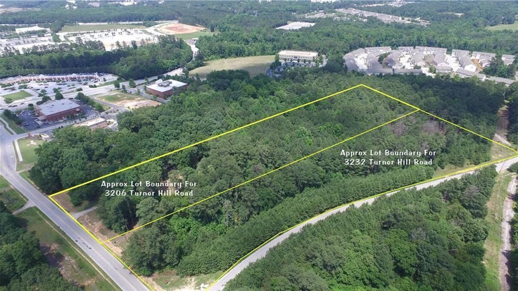
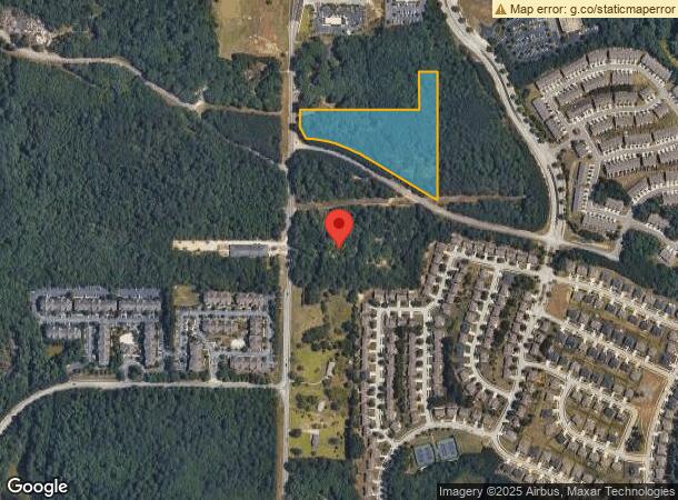
3232 Turner Hill Rd
Atlanta-Sandy Springs-Roswell, GA
TRACT 03-APR-06 3.85AC 104 X 700 X 225 X ...
16-182-01-001
DeKalb
Vacantlandnec
Georgia
X
1
13247C0080D
6.20 AC
2024
I-20 East/Conyers
2023
Atlanta
023440
DEMOGRAPHICS near 3232 Turner Hill Rd
1 Mile
3 Mile
5 Mile
2024 Total Population
5,461
27,125
102,433
2029 Population
5,515
27,584
103,385
Pop Growth 2024-2029
+ 0.99%
+ 1.69%
+ 0.93%
Average Age
37
38
38
2024 Total Households
2,321
10,604
37,909
HH Growth 2024-2029
+ 0.60%
+ 1.33%
+ 0.79%
Median Household Inc
$93,438
$59,229
$60,993
Avg Household Size
2.30
2.50
2.60
2024 Avg HH Vehicles
2.00
2.00
2.00
Median Home Value
$257,524
$214,235
$184,035
Median Year Built
1994
1995
1993
Nearby Places
- Restaurants
- Banks
- Shops
- Fitness
- Groceries
PUBLIC TRANSPORTATION
AIRPORT
Hartsfield - Jackson Atlanta International
DRIVE
WALK
Distance
Hartsfield - Jackson Atlanta International
34 min
23.8 mi
Freight Ports
Georgia Ports - Savannah
DRIVE
WALK
Distance
Georgia Ports - Savannah
278 min
241.0 mi
SALE & LEASE HISTORY
LISTING DATE
SALE/LEASE

Oct 05, 2023
For Sale
Feb 05, 2024
For Sale
Nearby Properties
Address
Land Use
TOTAL SIZE
Lot Size
Zoning
Address
Land Use
TOTAL SIZE
Lot Size
Zoning
224,892 SF
18 AC
RM100
Address
Land Use
TOTAL SIZE
Lot Size
Zoning
257,807 SF
29.90 AC
RM100
Address
Land Use
TOTAL SIZE
Lot Size
Zoning
274,631 SF
25 AC
RM100
Address
Land Use
TOTAL SIZE
Lot Size
Zoning
764,622 SF
44.70 AC
M
Address
Land Use
TOTAL SIZE
Lot Size
Zoning
224,155 SF
23.40 AC
X
Address
Land Use
TOTAL SIZE
Lot Size
Zoning
405,288 SF
29 AC
C1
Address
Land Use
TOTAL SIZE
Lot Size
Zoning
235,521 SF
15.10 AC
RM75
Address
Land Use
TOTAL SIZE
Lot Size
Zoning
2,782 SF
29.51 AC
R3/C
Address
Land Use
TOTAL SIZE
Lot Size
Zoning
194,186 SF
18.50 AC
RM100
Address
Land Use
TOTAL SIZE
Lot Size
Zoning
108,519 SF
14.31 AC
Address
Land Use
TOTAL SIZE
Lot Size
Zoning
28,024 SF
11.24 AC
R1
Address
Land Use
TOTAL SIZE
Lot Size
Zoning
1,810 SF
234 AC
RA8
Address
Land Use
TOTAL SIZE
Lot Size
Zoning
267,899 SF
47.90 AC
X
Address
Land Use
TOTAL SIZE
Lot Size
Zoning
140,058 SF
8.10 AC
C1
Address
Land Use
TOTAL SIZE
Lot Size
Zoning
20,964 SF
25.29 AC
R3/C
Address
Land Use
TOTAL SIZE
Lot Size
Zoning
417,378 SF
31.95 AC
M1
Address
Land Use
TOTAL SIZE
Lot Size
Zoning
273,000 SF
15.41 AC
M1
Address
Land Use
TOTAL SIZE
Lot Size
Zoning
314,474 SF
24.70 AC
RM75
Address
Land Use
TOTAL SIZE
Lot Size
Zoning
124,591 SF
13.60 AC
C2
Address
Land Use
TOTAL SIZE
Lot Size
Zoning
48,531 SF
13.10 AC
C1
Address
Land Use
TOTAL SIZE
Lot Size
Zoning
181,160 SF
15.60 AC
M
Address
Land Use
TOTAL SIZE
Lot Size
Zoning
59,763 SF
12.52 AC
C-1
Address
Land Use
TOTAL SIZE
Lot Size
Zoning
96,725 SF
0.02 AC
C1
Address
Land Use
TOTAL SIZE
Lot Size
Zoning
173,427 SF
15.10 AC
X
Address
Land Use
TOTAL SIZE
Lot Size
Zoning
196,560 SF
12.06 AC
MI
Address
Land Use
TOTAL SIZE
Lot Size
Zoning
94,220 SF
4.60 AC
RM75
Address
Land Use
TOTAL SIZE
Lot Size
Zoning
263,339 SF
25.90 AC
C1
Address
Land Use
TOTAL SIZE
Lot Size
Zoning
1,968 SF
26.91 AC
M2
Address
Land Use
TOTAL SIZE
Lot Size
Zoning
713,040 SF
67.04 AC
M1
Address
Land Use
TOTAL SIZE
Lot Size
Zoning
65,460 SF
32.41 AC
M1
The World's #1 Commercial Real Estate Marketplace
Connect with us
© 2025 CoStar Group
The information above has been obtained from sources believed reliable. While we do not doubt its accuracy we have not verified it and make no guarantee, warranty or representation about it. It is your responsibility to independently confirm its accuracy and completeness. Any projections, opinions, assumptions, or estimates used are for example only and do not represent the current or future performance of the property. The value of this transaction to you depends on tax and other factors which should be evaluated by your tax, financial, and legal advisors. You and your advisors should conduct a careful, independent investigation of the property to determine to your satisfaction the suitability of the property for your needs.